
Since last fall, NASA scientists have flown an advanced 3D Doppler wind lidar instrument across the United States to collect nearly 100 hours of data — including a flight through a hurricane. The goal? To demonstrate the unique capability of the Aerosol Wind Profiler (AWP) instrument to gather extremely precise measurements of wind direction, wind speed, and aerosol concentration – all crucial elements for accurate weather forecasting.
News
NASA Tracks Snowmelt to Improve Water Management

As part of a science mission tracking one of Earth’s most precious resources – water – NASA’s C-20A aircraft conducted a series of seven research flights in March that can help researchers track the process and timeline as snow melts and transforms into a freshwater resource. The agency’s Uninhabited Aerial Vehicle Synthetic Aperture Radar (UAVSAR) installed on the aircraft collected measurements of seasonal snow cover and estimate the freshwater contained in it.
NASA Airborne Sensor’s Wildfire Data Helps Firefighters Take Action
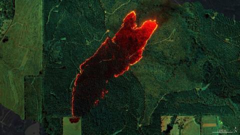
Data from the AVIRIS-3 sensor was recently used to create detailed fire maps in minutes, enabling firefighters in Alabama to limit the spread of wildfires and save buildings. A NASA sensor recently brought a new approach to battling wildfire, providing real-time data that helped firefighters in the field contain a blaze in Alabama. Called AVIRIS-3, which is short for Airborne Visible Infrared Imaging Spectrometer 3, the instrument detected a 120-acre fire on March 19 that had not yet been reported to officials.
Testing in the Clouds: NASA Flies to Improve Satellite Data

In February, NASA’s ER-2 science aircraft flew instruments designed to improve satellite data products and Earth science observations. From data collection to processing, satellite systems continue to advance, and NASA is exploring how instruments analyzing clouds can improve data measurement methods.
NASA Measures Moonlight to Improve Earth Observations

Flying high above the clouds and moon-gazing may sound like a scene from a timeless romance, but NASA did just that in the name of Earth science research. In March 2025 pilots took the agency’s ER-2 science aircraft on a series of night flights over NASA’s Armstrong Flight Research Center in Edwards, California, as the Moon increased in visible size. For those few nights, the high-flying plane was converted into a one-of-a-kind airborne lunar observatory.
NASA Supports Wildland Fire Technology Demonstration

Advancements in NASA’s airborne technology have made it possible to gather localized wind data and assess its impacts on smoke and fire behavior. This information could improve wildland fire decision making and enable operational agencies to better allocate firefighters and resources. A small team from NASA’s Armstrong Flight Research Center in Edwards, California, is demonstrating how some of these technologies work.
NASA Uses New Technology to Understand California Wildfires

The January wildfires in California devastated local habitats and communities. In an effort to better understand wildfire behavior, NASA scientists and engineers tried to learn from the events by testing new technology. The new instrument, the Compact Fire Infrared Radiance Spectral Tracker (c-FIRST), was tested when NASA’s B200 King Air aircraft flew over the wildfires in the Pacific Palisades and Altadena, California. Based at NASA’s Armstrong Flight Research Center in Edwards, California, the aircraft used the c-FIRST instrument to observe the impacts of the fires in near real-time. Due to its small size and ability to efficiently simulate a satellite-based mission, the B200 King Air is uniquely suited for testing c-FIRST.
NASA Tests Drones to Provide Micrometeorology, Aid in Fire Response
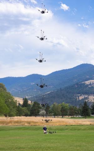
In Aug. 2024, a team of NASA researchers and partners gathered in Missoula, Montana to test new drone-based technology for localized forecasting, or micrometeorology. Researchers attached wind sensors to a drone, NASA’s Alta X quadcopter, aiming to provide precise and sustainable meteorological data to help predict fire behavior.
NASA Explores Earth Science with New Navigational System

NASA and its partners recently tested an aircraft guidance system that could help planes maintain a precise course even while flying at high speeds up to 500 mph. The instrument is Soxnav, the culmination of more than 30 years of development of aircraft navigation systems. NASA’s G-IV aircraft flew its first mission to test this navigational system from NASA’s Armstrong Flight Research Center in Edwards, California, in December 2024. The team was composed of engineers from NASA Armstrong, NASA’s Jet Propulsion Laboratory in Southern California, and the Bay Area Environmental Research Institute (BAERI) in California’s Silicon Valley.
NASA Radar Imagery Reveals Details About Los Angeles-Area Landslides

Researchers at NASA’s Jet Propulsion Laboratory in Southern California used data from an airborne radar to measure the movement of the slow-moving landslides on the Palos Verdes Peninsula in Los Angeles County. The analysis determined that, during a four-week period in the fall of 2024, land in the residential area slid toward the ocean by as much as 4 inches (10 centimeters) per week.
PACE-PAX: A Day in the Life of a NASA Field Campaign

The breeze across the California desert kicks up some dust and sand. As a NASA research plane rolls down the runway and prepares for takeoff, its wings vibrate with the gust of wind. It’s a flight day for one of NASA’s most expansive and complex field campaigns.
NASA’s C-20A Studies Extreme Weather Events

On a changing planet, where phenomena like severe hurricanes, landslides, and wildfires are becoming more severe, scientists need data to assess and model disaster impacts and to potentially make predictions about hazards. NASA’s C-20A aircraft is a significant asset that can carry key instruments for understanding the science behind these phenomena.
NASA and Forest Service Use Balloon to Help Firefighters Communicate
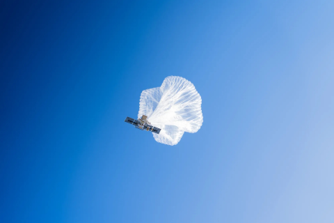
The flight testing of the Strategic Tactical Radio and Tactical Overwatch (STRATO) technology brought together experts from NASA’s Ames Research Center in California’s Silicon Valley, the U.S. Forest Service, high-altitude balloon company Aerostar, and Motorola to provide cell service from above. The effort was funded by the NASA Science Mission Directorate’s Earth Science Division Airborne Science Program and the agency’s Space Technology Mission Directorate Flight Opportunities program.
Validating PACE and Inspiring Future Scientists

This story is from one of 63 virtual student engagement events held for NASA’s Plankton, Aerosol, Cloud, ocean Ecosystem Postlaunch Airborne Experiment (PACE-PAX). The mission used aircraft (the NASA ER-2 and CIRPAS Twin Otter) and waterborne research vessels (R/V Blissfully,R/V Shearwater, and R/V Fish) to calibrate and validate the data from the PACE satellite, which was launched in February 2024. California was the main hub for the mission, with most of the airborne and waterborne activities occurring in Edwards, Marina, Long Beach, and Santa Barbara.
High-Altitude ER-2 Flights Get Down-to-Earth Data

Operating at altitudes above 99% of the Earth’s atmosphere, NASA’s ER-2 aircraft is the agency’s highest-flying airborne science platform. With its unique ability to observe from as high as 65,000 feet, the ER-2 aircraft is often a platform for Earth science that facilitates new and crucial information about our planet, especially when the plane is part of collaborative and multidisciplinary projects.
Twenty-one Hours a Day on a 30-Foot Floating Science Lab

Research Vessel (RV) Blissfully is a 30-foot sailboat that is the science lab and home for two sailing scientists, Captain Gordon Ackland and myself, Dr. Bridget Seegers. The RV Blissfully is a recent addition to the fleet of research vessels. Previously, Blissfully’s days were primarily spent peacefully floating snug in a San Diego boat slip with an occasional day sail. However, Blissfully was volunteered to support the PACE-PAX campaign and therefore transitioned a month ago into RV Blissfully.
Day-in-the-Life of a PACE-PAX Mission Flight

06:00 Local Time: Go/No-Go Meeting We are in the field supporting PACE-PAX (Plankton, Aerosol, Cloud, ocean Ecosystem Postlaunch Airborne eXperiment), a multi-disciplinary mission that involves two aircraft—the NASA ER-2 and CIRPAS Twin Otter—and several mobile ocean assets, all helping to validate observations and data products from NASA’s new satellite observation platform, PACE. Our days typically start with an initial look at the weather in the area of operations and airport conditions during takeoff and landing. Both the ER-2 and Twin Otter will fly today since the weather is acceptable for launch, science, and landing.
Sailing Away for PACE

Hello from sunny Santa Barbara, California, where the ship operations for the PACE-PAX campaign are underway!
The PACE satellite went into orbit in February 2024. Its mission is to help us better understand how the ocean and atmosphere exchange carbon dioxide, as well as how aerosols can fuel phytoplankton blooms and help us track harmful algal blooms around the planet.
PACE-PAX stands for Plankton, Aerosol, Cloud, ocean Ecosystem – Postlaunch Airborne eXperiment (see why we made it shorter?) We are using two airplanes and three ships, among other free-sailing instruments, to gather data that will tell us how well our shiny new satellite, PACE, is doing. We compare our planet-side data with the space-side data so we can make sure we are providing the very best information about the health of the world’s oceans.
NASA Earth Scientists Take Flight, Set Sail to Verify PACE Satellite Data

NASA - More than 100 scientists will participate in a field campaign involving a research vessel and two aircraft this month to verify the accuracy of data collected by NASA’s new PACE satellite: the Plankton, Aerosol, Cloud, ocean Ecosystem mission.
NASA G-IV Plane Will Carry Next-Generation Science Instrument

In June 2024, a new tail number swept the sky above NASA’s Armstrong Flight Research Center in Edwards, California. Pilots conducted flights of a Gulfstream IV (G-IV) to evaluate its handling characteristics and to familiarize pilots with it before it begins structural modifications. The research plane is joining the center’s fleet serving NASA’s Airborne Science program.
Beyond the Textbook: DC-8 Aircraft Inspires Students in Retirement

In May 2024, Idaho State University’s class of 2025 received a new learning tool from NASA. The DC-8 aircraft served the world’s scientific community for decades as a platform under NASA’s Airborne Science Program before retiring to Idaho State University (ISU) to provide a hands-on learning experience for students in the university’s aircraft maintenance technology program.
NASA Aircraft Gathers 150 Hours of Data to Better Understand Earth

Operating internationally over several countries this summer, NASA’S C-20A aircraft completed more than 150 hours of science flights across two months in support of Earth science research and overcame several challenges throughout its missions.
NASA Returns to Arctic Studying Summer Sea Ice Melt

The NASA-sponsored Arctic Radiation Cloud Aerosol Surface Interaction Experiment (ARCSIX) mission is flying three aircraft over the Arctic Ocean north of Greenland to study these processes. The aircraft are equipped with instruments to gather observations of surface sea ice, clouds, and aerosol particles, which affect the Arctic energy budget and cloud properties. The energy budget is the balance between the energy that Earth receives from the Sun and the energy the Earth loses to outer space.
Second Stop: The 2019 Arctic Tundra Fire in Greenland
.")
July 29th, 2024 by Sonja Granqvist/University of Helsinki A combined team from the University of Helsinki (Environmental Change Research Unit), the Finnish Meteorological Institute (Atmospheric Composition Unit), and the Vrije Universiteit Amsterdam (Climate & Ecosystems Change) was on its way again to gather groundbreaking data on carbon and aerosol emissions from increasing fires in the northern high latitudes. Our journey began in boreal Quebec and now continues to Arctic Greenland.
First Stop: Sampling the 2023 Fires in Quebec
.")
This blog post is the first in a series to come. Our team, the Climate & Ecosystems Change research group from the Vrije Universiteit Amsterdam, is working in collaboration with the Environmental Change Research Unit from the University of Helsinki for a summer with lots of fire field work, science, and adventure. On this journey, our first stop was the Quebec province in Canada. I’m writing this post after our last day of fieldwork here.
NASA-Led Mission to Map Air Pollution Over Both U.S. Coasts
")
This summer between June 17 and July 2, NASA will fly aircraft over Baltimore, Philadelphia, parts of Virginia, and California to collect data on air pollutants and greenhouse gas emissions. The campaign supports the NASA Student Airborne Research Program for undergraduate interns.
NASA Mission Flies Over Arctic to Study Sea Ice Melt Causes

It’s not just rising air and water temperatures influencing the decades-long decline of Arctic sea ice. Clouds, aerosols, even the bumps and dips on the ice itself can play a role. To explore how these factors interact and impact sea ice melting, NASA is flying two aircraft equipped with scientific instruments over the Arctic Ocean north of Greenland this summer. The first flights of the field campaign, called ARCSIX (Arctic Radiation Cloud Aerosol Surface Interaction Experiment), successfully began taking measurements on May 28.
NASA Teammates Recall Favorite Memories Aboard Flying Laboratory

After flying more than three decades and 158 science campaigns, just one flight remains. NASA’s DC-8 Airborne Science Laboratory will make its final flight May 15 to Idaho State University in Pocatello, Idaho, where it will be used to train future aircraft technicians by providing real-world experience in the college’s Aircraft Maintenance Technology Program.
Meet NASA Women Behind World’s Largest Flying Laboratory

NASA’s DC-8 aircraft – the world’s largest flying science laboratory – began its science missions in 1987 and since then, has flown in service of the science community over places like Antarctica, Greenland, and Thailand. Aircraft like the DC-8 have enabled scientists to ask questions about life on Earth and explore them in a way that only NASA’s Airborne Science program can make happen. After 37 years, the DC-8 will retire to Idaho State University, where it will serve as an educational tool for students.
As the DC-8 approaches its retirement, we highlight five of the women who have made the aircraft and program a success. Kirsten Boogaard, Nicki Reid, Carrie Worth, Erin Waggoner, and Wendy Bereda of NASA’s Armstrong Flight Research Center in Edwards, California, are building the legacy of women who are helping pave the way for the next generation.
NASA’s ORCA, AirHARP Projects Paved Way for PACE to Reach Space

It took the Plankton, Aerosol, Cloud, ocean Ecosystem (PACE) mission just 13 minutes to reach low-Earth orbit from Cape Canaveral Space Force Station in February 2024. It took a network of scientists at NASA and research institutions around the world more than 20 years to carefully craft and test the novel instruments that allow PACE to study the ocean and atmosphere with unprecedented clarity.